Commonwealth of Australia
Government type Federal parliamentary democracy under a constitutional monarchy
Area 7,688,095 km² (2,968,390 sq mi)
Population 25,423,000 inh. (2021 census)
Population 27,090,000 inh. (2024 est.)
Population density 3.5 inh/km² (9 inh/mi²)
Area 7,688,095 km² (2,968,390 sq mi)
Population 25,423,000 inh. (2021 census)
Population 27,090,000 inh. (2024 est.)
Population density 3.5 inh/km² (9 inh/mi²)
Capital Canberra (474,000 pop.)
Currency Australian dollar
Human development index 0.951 (5th place)
Languages English, aboriginal languages
Life expectancy M 81 years, F 85 years
Currency Australian dollar
Human development index 0.951 (5th place)
Languages English, aboriginal languages
Life expectancy M 81 years, F 85 years
External Territories Ashmore and Cartier Islands (2 km² - 0.8 sq mi, 0 pop.)
External Territories Christmas Island (136 km² - 52.5 sq mi, 1,690 pop.)
External Territories Cocos (Keeling) Islands (14 km² - 5.4 sq mi, 590 pop.)
External Territories Coral Sea Islands (81 km² - 31 sq mi, 0 pop.)
External Territories Heard Island and McDonald Islands (370 km² - 143 sq mi, 0 pop.)
Boundaries:
Indian Ocean NORTH-WEST, WEST and SOUTH
Pacific Ocean EAST amd NORTH-EAST
GEOGRAPHY DATA OF AUSTRALIA
Largest cities
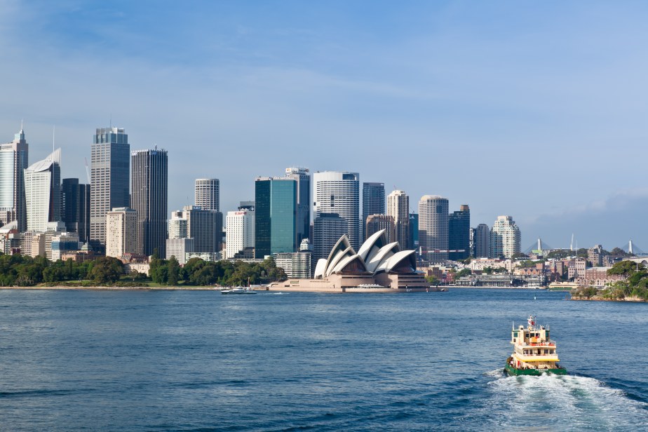
Sydney 4,699,000 pop., 4,836,000 urban aggl.
Melbourne 4,586,000 pop., 4,709,000 urban aggl.
Brisbane 2,288,000 pop., 3,039,000 urban aggl.
Perth 2,044,000 pop., 2,101,000 urban aggl.
Adelaide 1,245,000 pop., 1,271,000 urban aggl.
Gold Coast 671,000 pop.
Canberra 474,000 pop.
Highest mountains
Mount Kosciusko 2,228 m (7,310 ft)
Mount Townsend 2,209 m (7,247 ft)
Longest rivers
Darling 2,740 km (1,703 mi)
Murray 2,520 km (1,566 mi)
Murrumbidge 1,575 km (979 mi)
Lachlan 1,370 km (851 mi)
Cooper Creek 1,113 km (692 mi)
Flinders 1,004 km (624 mi)
Largest lakes
Eyre 9,500 km² (3,668 sq mi)
Torrens 5,745 km² (2,218 sq mi)
Gairdner 4,351 km² (1,680 sq mi)
Mackay 3,494 km² (1,349 sq mi)
Largest islands
Tasmania 64,519 km² (24,911 sq mi)
Melville 5,786 km² (2,234 sq mi)
Kangaroo Island 4,416 km² (1,705 sq mi)
Groote Eylandt 2,285 km² (882 sq mi)
Bathurst 1,693 km² (654 sq mi)
Fraser 1,653 km² (638 sq mi)
Flinders 1,359 km² (525 sq mi)
King 1,091 km² (421 sq mi)
Mornington 1,002 km² (387 sq mi)
ADMINISTRATIVE DIVISIONS OF AUSTRALIA
Australia is administratively divided into 6 States and 2 Territories, with Western Australia making up about 1/3 of the entire federal territory; New South Wales and Victoria are the 2 most populated states, thanks to the presence of the two Australian metropolises Sydney and Melbourne, while in the Northern Territory, which exceeds them in terms of surface area, only 260,000 people live.Most of the major cities are located along the south and east coasts, with a few exceptions, including the only major city on the west coast, Perth; in all there are 30 urban centers with at least 50,000 inhabitants, with two of these in Tasmania and Western Australia and one each in the Northern Territory and in South Australia.