Home > North America > Grenada

Grenada
Government type Parliamentary constitutional monarchy
Area 344 km² (133 sq mi)
Population 106,700 inh. (2011 census)
Population 126,900 inh. (2024 est.)
Population density 369 inh/km² (954 inh/mi²)
Area 344 km² (133 sq mi)
Population 106,700 inh. (2011 census)
Population 126,900 inh. (2024 est.)
Population density 369 inh/km² (954 inh/mi²)
Capital St. George's (38,300 pop.)
Currency Eastern Caribbean dollar
Human development index 0.795 (68th place)
Languages English (official), Creole-English, Patois (Creole-French dialect)
Life expectancy M 73 years, F 79 years
Currency Eastern Caribbean dollar
Human development index 0.795 (68th place)
Languages English (official), Creole-English, Patois (Creole-French dialect)
Life expectancy M 73 years, F 79 years
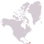
Boundaries:
Surrounded by the Atlantic Ocean
GEOGRAPHY DATA OF GRENADA
Largest cities
St. George's 38,300 pop.
Highest mountains
Mount Saint Catherine 840 m (2,756 ft)
Largest lakes
Grand Etang 0.04 km² (0.015 sq mi)
Largest islands
Grenada 306 km² (118 sq mi)
Carriacou 34 km² (13.1 sq mi)
Ronde Island 2.7 km² (1 sq mi)
Petit Martinique 2.4 km² (0.9 sq mi)