
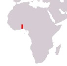
Togolese Republic
République Togolaise
République Togolaise
Government type Presidential republic
Area 56,785 km² (21,925 sq mi)
Population 8,095,000 inh. (2022 census)
Population density 143 inh/km² (369 inh/mi²)
Area 56,785 km² (21,925 sq mi)
Population 8,095,000 inh. (2022 census)
Population density 143 inh/km² (369 inh/mi²)
Capital Lomé (1,350,000 pop., 2,572,000 urban aggl.)
Currency West African CFA franc
Human development index 0.539 (162nd place)
Languages French (official), regional languages
Life expectancy M 62 years, F 67 years
Currency West African CFA franc
Human development index 0.539 (162nd place)
Languages French (official), regional languages
Life expectancy M 62 years, F 67 years
GEOGRAPHY DATA OF TOGO
Largest cities
Lomé 1,350,000 pop., 2,572,000 urban aggl.
Kara 121,000 pop.
Sokodé 114,000 pop.
Highest mountains
Mount Agou 986 m (3,235 ft)
Longest rivers
Oti 520 km (323 mi) total, with sections in Burkina Faso and Ghana
Mono 400 km (249 mi)
Largest lakes
Lake Togo 64 km² (25 sq mi)
ADMINISTRATIVE DIVISIONS OF TOGO
Togo is administratively divided into 5 regions, with Plateaux being the largest, while Maritime, despite being the smallest in area, is by far the most populated, with over 3 million inhabitants.At the last census, excluding Lomé, no city exceeded one hundred thousand inhabitants, with Sokodé and Kara however very close to this threshold; the distribution of the major urban centers is fairly well balanced between the various regions, as can be seen in the second map.