
Union of the Comoros
Jumhuriyat al Qamar al Muttahidah
Udzima wa Komori
Union des Comores
Jumhuriyat al Qamar al Muttahidah
Udzima wa Komori
Union des Comores
Government type Federal presidential republic
Area 1,861 km² (719 sq mi)
Population 758,000 inh. (2017 census)
Population 886,000 inh. (2024 est.)
Population density 476 inh/km² (1,232 inh/mi²)
Area 1,861 km² (719 sq mi)
Population 758,000 inh. (2017 census)
Population 886,000 inh. (2024 est.)
Population density 476 inh/km² (1,232 inh/mi²)
Capital Moroni (75,000 pop.)
Currency Comorian franc
Human development index 0.558 (156th place)
Languages Arabic, Comorian, French (all official)
Life expectancy M 62 years, F 66 years
Currency Comorian franc
Human development index 0.558 (156th place)
Languages Arabic, Comorian, French (all official)
Life expectancy M 62 years, F 66 years
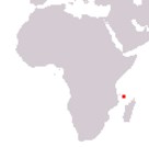
Boundaries:
Surrounded by the Indian Ocean
GEOGRAPHY DATA OF COMOROS
Largest cities
Moroni 75,000 pop.
Mutsamudu 30,000 pop.
Fomboni 18,300 pop.
Domoni 16,300 pop.
Highest mountains
Mount Kartala 2,361 m (7,746 ft)
Largest islands
Grande Comore 1,146 km² (442 sq mi)
Anjouan 424 km² (164 sq mi)
Mohéli 290 km² (112 sq mi)